

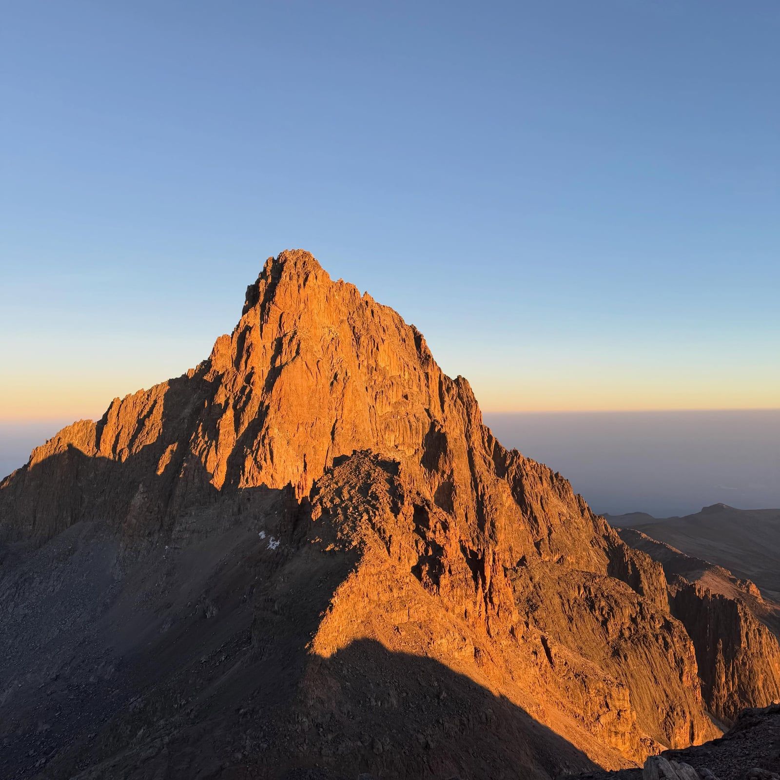
Twelve receding glaciers cling to the jagged 5,199-meter summit of this extinct equatorial volcano. You'll hike past giant lobelias in the afro-alpine moorland to reach Point Lenana at dawn, watching the sun hit the ice-streaked spires of Batian and Nelion.
Find Guided ToursMount Kenya is an extinct volcano straddling the equator, 193 km north-northeast of Nairobi. It erupted between 3.1 and 2.6 million years ago, pushing up to roughly 6,500 meters before millions of years of erosion stripped it down to its current 5,199-meter height. Today, it's Africa's second-highest mountain. The jagged summit block holds three main peaks: Batian (5,199 m) and Nelion (5,188 m), which require technical rock climbing, and the trekking destination Point Lenana at 4,985 m.
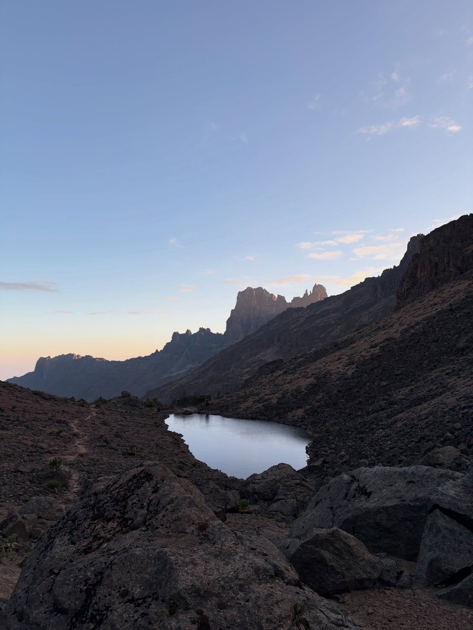
Twelve remnant glaciers cling to the upper slopes, though they're all receding rapidly. Below the ice, about 20 glacial tarns sit in U-shaped valleys between 3,950 and 4,800 meters. The mountain is a massive water tower. It supplies roughly half of Kenya's population with fresh water and generates about 70% of the country's hydroelectric power.
The Kikuyu and Meru peoples consider the mountain holy. They believe their God Ngai and his wife Mumbi live at the very top. To protect the afro-alpine flora—like giant lobelias and towering groundsels—the area was gazetted as a Forest Reserve in 1932 and a National Park in 1949. UNESCO designated it a World Heritage Site in 1997.
European climbers first reached the highest point on September 13, 1899, when Sir Halford John Mackinder, Cesar Ollier, and Josef Brocherel stood on Batian. Eric Shipton and Percy Wyn-Harris followed decades later, summiting the second-highest peak, Nelion, on January 6, 1929. If you're hiking up, you'll walk through montane rainforests and bamboo belts before hitting the stark alpine desert near the summit.

Discover the full history and cultural significance on our About page.
Time your final push between 3:00 and 6:30 AM to reach the 4,985-meter summit. Morning light hits the jagged, ice-streaked spires of Batian and Nelion first, while the plains of Kenya spread out far below. It's a steep climb in thin air. The early start pays off immediately.
This 40-kilometer eastern approach covers the mountain's most dramatic terrain. Hikers pass the rushing Nithi Falls and the turquoise waters of Lake Ellis before the path reveals Lake Michaelson, cupped entirely by sheer cliffs. Ascend this way, then descend via Naro Moru to cover completely different ecosystems.
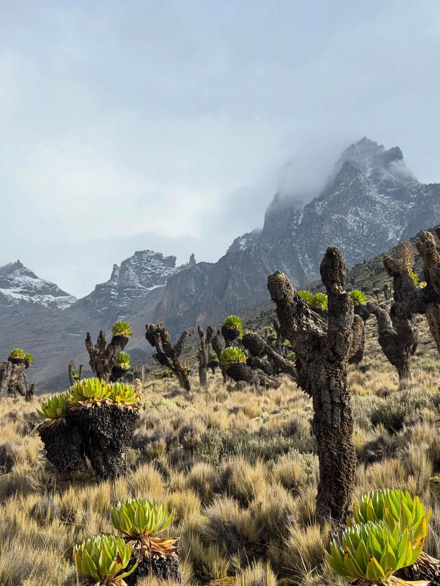
Above 3,000 meters, the bamboo belt gives way to an afro-alpine moorland. Giant lobelias and towering groundsels rise like strange sculptures against the misty highland light. These bizarre endemic plants grow almost nowhere else on Earth. Trekkers spend two nights in this zone just to acclimatize.
The lower montane forest and bamboo zones hide some of Mount Kenya's rarest large mammals. Walk quietly on the lower trails to spot black rhinos, giant forest hogs, or tree hyraxes. The critically endangered mountain bongo also lives here, though seeing one requires serious luck.
Book a trek or day trip starting at $276, with hotel pickup and free cancellation up to 24 hours.
Swipe to see more
Target the dry seasons from January to March or June to October. You get firmer trails, clearer skies, and much safer river crossings.
The long rains arrive, turning sections like the Naro Moru Vertical Bog into impassable mud. Fog rolls in heavily, and rangers frequently alter or close routes. Skip this window.
Skies clear up and the mud dries out. July and August bring cooler temperatures and excellent wildlife viewing on the lower slopes. River crossings become much safer.
September and October offer prime trekking conditions and cooler temperatures. Then November brings the short rains, turning the mountain slippery and wet. Finish your trek before November starts.
January and February sit squarely in the dry season. Trails harden, skies clear up, and conditions are ideal for a pre-dawn summit push to Point Lenana.
Mount Kenya National Park is open every day of the year, including public holidays. You can enter and exit through the main gates—Sirimon, Naro Moru, and Chogoria—between 6:00 AM and 6:00 PM. Once inside, your ticket remains valid for 24 hours. Don't plan on moving through the gates after dark. Night access requires prior written approval from the Kenya Wildlife Service, though overnight climbers already on the mountain are exempt from the evening curfew.
| Category | Price |
|---|---|
| East Africa Citizen Adult | KES 800 |
| East Africa Citizen Child (3-17) | KES 400 |
| Kenya Resident Adult | KES 1,100 |
| Kenya Resident Child | KES 550 |
| African Passport Holder Adult (non-EAC) | USD 30 |
| African Passport Holder Child (non-EAC) | USD 15 |
| Non-Resident Adult | USD 70 |
| Non-Resident Child | USD 35 |
| Children under 5 | Free |
| Mountain climbing permit (Citizen/Resident) | KES 1,500 |
| Mountain climbing permit (Non-Resident) | USD 30 |
| Private vehicle (up to 6 seats) | KES 600 |
Cash is not accepted at any gate. You must book and pay for all entry, camping, and climbing permits in advance using the KWSPay platform on eCitizen. The 2025 tariff increases are currently under judicial review following a legal challenge by the Kenya Tourism Federation. Check current rates on KWSPay before your trip, as fees or refund policies could shift depending on the court's ruling.
For complete schedules and ticket prices, visit our Hours & Fees page.
Most travelers start in Nairobi and head north by road or air to base towns like Nanyuki or Chogoria. From these towns, you'll need a private vehicle or local taxi to cover the final stretch to the park gates.
📍 Central Kenya, 193 km north-northeast of Nairobi
Shared minibuses and long-distance buses leave daily from Nairobi's Nyamakima or Tea Room terminals. They run to base towns like Nanyuki, Chogoria, Embu, and Meru. You'll reach the Nanyuki or Chogoria area after about four to five hours on the road. Public transit doesn't enter the park itself. You have to hire a local taxi or boda-boda for the final leg to the gates.
Driving yourself takes about three to four hours from Nairobi. Sirimon Gate sits 200 km away off the Nanyuki-Meru Road, while Naro Moru Gate is 188 km north along the Nyeri-Nanyuki road. Chogoria Gate is roughly 210 km out on the Embu-Meru Road. Bring a 4x4. The gate access roads get muddy and rutted during wet weather.
Scheduled and charter flights depart from Nairobi's Wilson Airport. They land at the commercial airstrip in Nanyuki, the closest aviation hub to the mountain. The flight covers the 193 km distance fast. You touch down in under an hour. From the airstrip, trekking companies or local lodges usually arrange your onward road transport straight to the park gates.
No direct public transit connects Nanyuki town to the national park. Visitors must hire a local taxi, a boda-boda, or use arranged lodge transport. The drive to nearby entrances like Naro Moru or Sirimon takes up to an hour. Fares depend entirely on what you negotiate with the local drivers. Set your price before getting in.
For detailed transport options and routes, visit our Directions page.
Cash is dead at the gates. You have to book and pay for all entry, camping, and climbing permits in advance through the KWSPay platform on eCitizen. Double-check the current rates before you log on. A 2025 fee hike is tied up in court, so prices might fluctuate.
Altitude sickness hits hard above 3,000 meters. Oxygen levels drop by roughly 40 percent near the summit, making the air noticeably thin. Build at least two nights at this elevation into your itinerary to adjust. If a headache or nausea sets in, descend immediately.
Temperatures drop rapidly from 25 Celsius at the base to -5 Celsius near the summit. Weather often changes within the exact same day. Pack thermal base layers, a fleece, a down jacket, and a waterproof outer shell. Leave single-use water bottles behind, as the park is a strict plastic-free zone.
The Naro Moru route is the shortest way up, but it comes with a miserable obstacle. Just above the forest line, the Vertical Bog turns into a steep, waterlogged mess of tussock grass. Expect thigh-deep mud after heavy rain. Wear waterproof hiking boots and stay on the marked trail.
Aim to leave high camp between 3:00 and 6:30 AM for the final climb to Point Lenana. Early mornings offer the most stable weather and clear visibility. Afternoon clouds and heavy fog regularly roll in to obscure the peaks. You want to be descending by the time that happens.
You cannot hike this mountain alone. Park rules mandate a licensed guide for all treks, and you need a separate climbing permit for the summits. Check that your crew carries valid KWS ID cards. Unlicensed operators will just get you turned away at the gate.
This conservancy protects East Africa's largest black rhino population and the world's last northern white rhinos. You'll also find a chimpanzee sanctuary alongside lions and elephants.
A 9.8-kilometer elephant corridor links this reserve directly to the mountain. It holds the world's largest resident group of Grevy's zebras, plus both black and white rhinos.
A suspended canopy walkway cuts through the ancient trees of this indigenous forest. Families can walk the gentler trails and swim in natural pools fed by clear streams.
Read what travelers share about their experience visiting Mount Kenya — from practical tips to personal highlights.


Planning advice, comparisons, and practical tips.

Most visitors who base themselves in Nanyuki, Naro Moru or Chogoria never intend to spend five or six days climbing to Point Lenana. They want a day…

Where you sleep on Mount Kenya depends on why you're there. Trekkers aiming for Point Lenana bunk down in stone huts above 3,000m; wildlife-watchers…

Climb Mount Kenya in January–March or June/July–October and you'll hit the mountain's two dry windows: firmer trails, clear ridgelines, and safer…

A guided climb up Mount Kenya can cost anywhere from $700 to $5,000 per person, and the gap has almost nothing to do with luck. It comes down to…
Non-resident adults pay USD 70 for a 24-hour ticket, while East African citizens pay KES 800. You have to pay in advance through the KWSPay platform on eCitizen, since cash isn't accepted at the gates.
The dry seasons from January to March and late June to October have the clearest skies. Avoid the long rains of March through May and the short November rains. These storms turn routes like the Naro Moru trail into deep mud.
Matatus and buses run daily from Nairobi to Nanyuki or Chogoria, taking four to five hours and costing between KES 700 and KES 1,200. From there, you hire a local taxi for the 30- to 60-minute ride to your chosen park gate. You can also fly from Wilson Airport to Nanyuki in about 45 minutes.
No, hiking alone is strictly prohibited inside the national park. You must hire a KWS-licensed guide for all treks, and anyone attempting summits like Point Lenana needs a separate mountain climbing permit booked via eCitizen.
Temperatures drop from 25 C at the base to -5 C near the peaks. You'll need thermal base layers, a down jacket, and waterproof outer shells. Bring a reusable water bottle since the park bans all single-use plastics.
The lower elevations are highly accessible, with paved access roads at the Naro Moru and Sirimon gates. Lodges like Serena Mountain Lodge have wheelchair-friendly rooms and level boardwalks for forest viewing. Ascending above 3,000 meters requires strong fitness and isn't recommended for those with cardiovascular conditions.
A standard round-trip trek to Point Lenana at 4,985 meters takes four to six days depending on your route. Technical climbs to the higher Batian or Nelion peaks require six to eight days. Day visitors can explore the lower forest zones and gates in just a few hours.
Trekkers face a real risk of altitude sickness above 3,000 meters. Oxygen levels near the summit are 40 percent lower than at sea level. Spend at least two nights above 3,000 meters to acclimatize, and descend immediately if you feel dizzy.
Browse verified tours with free cancellation and instant confirmation.
Find Tours


